
Welcome to the fifteenth OpenStreetMap NextGen development diary.
I am sorry for the delay in the development diary! Due to my participation in the recent State of the Map EU 2024, I had to dedicate some of my time to making the presentations and attending the event. Nonetheless, thanks to other project contributors, we have more highlights to show off! This is the beauty of an open community collaboration 🙂.
🔖 You can read other development diaries here:
osm.org/user/NorthCrab/diary/
⭐ This project is open-source — join us today:
https://github.com/openstreetmap-ng/openstreetmap-ng
🛈 This initiative is not affiliated with the OpenStreetMap Foundation.
Multiple Changeset Bounding Boxes
OpenStreetMap-NG is resolving one of the most common newbie issues on OpenStreetMap while making area monitoring more accurate. Changesets now support incremental and deterministic clustering of changes, enabling multiple bounding box support.
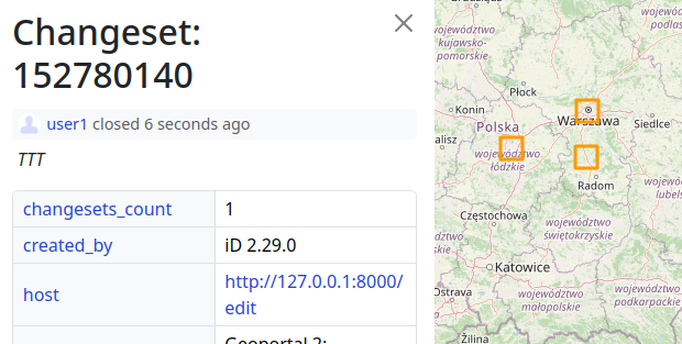
This change is backwards compatible, as API 0.6 and others will continue to return a single bounding box per changeset. This feature will only be available directly on the website, as well as in API 0.7.
Let’s mark the end for issues like these:
Why it’s bad: Everyone monitoring for changes within the bounding box receives a notification. When a single changeset covers half of the world, this leads to a lot of noise, making the system less reliable and difficult to follow.
Implementation of Recent Activity Chart
We have also finished the implementation of the recent activity chart, which is displayed on user profiles. Originally announced in Development Diary #11.
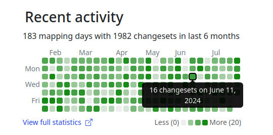
This feature will make it easier to moderate and monitor activity on OpenStreetMap, providing a quick peek at the recent mapping experience of a user.
Updated Geolocation Icon
We have received feedback that the existing geolocation icon is confusing, making some people unaware of this feature. We are now experimenting with a new, more typical design for it:
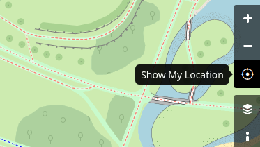
In the future, we will make the new icon theme match the surrounding icons. Currently, the icon appears a little too thin.
Feature-Parity Process
This week, we have also made progress towards reaching the feature-parity goal. This includes final development of the search functionality and the “Where is this?” feature. We have also corrected a few small bugs and added support for Data Layer alert auto-dismissal.
Simplified Authorization System
During the recent State of the Map EU 2024, I received a hint that the authorization system could be made even simpler, making it easier to test and maintain. We no longer have a separate system for handling user session tokens (cookies); we are now reusing OAuth2 core with a simple wrapper on top of it. Nothing has changed functionally, there’s simply less code. Win-win-win \🙂/.
Sponsors
This two week’s work was sponsored by 17 people!
8 donors on Liberapay, and 9 on GitHub Sponsors.
Harder, Better, Faster, Stronger — Together! Thank you all!
- ~1847430
- gileri (Eric G.)
- LaoshuBaby (快乐的老鼠宝宝)
- mutipg
- RedAuburn (Harry Bond)
- ~1819511
- AurimasF (Aurimas Fišeras)
- starsep
- gander (Adam Gąsowski)
- owiecc (Szymon Bęczkowski)
- kkalata (Kamil Kalata)
- bryceco
- angoca (Andres Gomez Casanova)
Please consider supporting the OpenStreetMap-NG development with any amount. As a thank you, you will be eligible for the unique OpenStreetMap-NG Founder profile badge. You will also help to push the project forward 🏋.