
Inspired by Xvtn’s OSM Iceberg meme, I made my own personal recollections based on my own experiences.
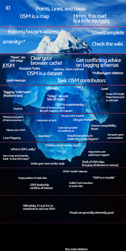
Level 1
- OSM is a map : Especially the default OSM Carto basemap that is used in various places outside of OpenStreetMap.org itself. Some people probably first encounter the name ‘OpenStreetMap’ through the attached attribution label on that basemap.
- iD : The default web-based data editor on openstreetmap.org. The “hello world” of OpenStreetMap. Every OSM contributor (probably) starts here.
- Points, Lines, and Areas : These are the things that you can add to OpenStreetMap.
- Hmm, this road is a little squiggly : (Can’t relate. I rarely edit the road network on OSM.)
Level 2
- Amenity=*: The first introduction to the intricacies of the OSM tagging scheme.
- Check the wiki : More intricacies of the OSM tagging scheme.
- StreetComplete : “Oh, so we can add data to OSM without using iD?”
- Add my house’s address : (Can’t relate. I usually add significant POIs on OSM, not my own house.)
Level 3
- Clear your browser caches! : Repeatedly press the Ctrl + F5 button to view the map update based on our recent OSM contribution. It’s truly satisfying to see the changes. (However, please note that some large area edits on a low zoom level might take more time.)
- Opening_hours madness : Some OSM tagging schemes are quite… really difficult to understand.
- Get conflicting advice on tagging schemas : Some OSM tagging schemes are quite… inconsistent.
- “Areas” are just ways : The first introduction to the OSM data model. It’s actually “nodes, ways and relations”, not “points, lines and areas”.
- Multipolygon relations : OSM relations are hard.
- JOSM : The OpenStreetMap editor for power users.
- Overpass Turbo : Search for specific OSM data and download it.
- OSM is a dataset : After realizing the truth about the OSM data model, its tagging intricacies, its variety of third-party editing tools, and the fact that we can “download the data back” by using Overpass, OSM is not merely a “map” anymore. Yes. Now, OSM is a dataset.
- Local meetups : Get in touch with the community.
- Toxic OSM contributors : Get in touch with the community (went wrong).
Level 4
- Tagging “Wild West” (freeform text) : Some OSM tagging schemes are quite… anarchy.
- Clash of factions/cliques like golf-mappers, rail-mappers : Some OSM tagging schemes are quite… political.
- Level : (Surprisingly, I don’t know anything about this. I know about layer though.)
- Edit wars : Get in touch with the community (went really wrong).
- “Ways” are just lists of nodes : Slow realization about the truth behind the OSM data model. (And yes, relations are just ordered lists of nodes/ways/relations)
- Swear off Google Maps forever, just on principle : (Yes. But in my case, it’s probably just a phase.)
- Vespucci : The OpenStreetMap editor for power users (on mobile!).
- OSM is a community :) : A map? A dataset? No! OSM is a community :)
Level 5
- Thriving ecosystem of data consumers : A slow realization about the existence of third-party OSM data consumers, which makes our OSM edits visible in unexpected places. Random maps on web/apps sometimes show data that we added to OSM, and it can be surprising and exciting.
- Do your own imports : (Can’t relate, I’m actually scared to do my own data imports because I don’t want to risk damaging the OSM database with a poorly executed import.)
- License compatibility issues : (Can’t relate, did I already tell you that I rarely perform data imports myself?)
- boundary=*: (Can’t relate. In my case, only official government organizations have access to boundary data. I rarely import data from them.)
- Should everything be made into multipolygons? : (Can’t relate, I usually map simple things and don’t encounter the need to create multipolygons often.)
- Geocoders all suck : (Can’t relate, I rarely use OSM-based geocoders.)
- Rampant spam and vandalism : (Slightly can’t relate. I usually map simple things and then just move on. I don’t actively defend my past contributions anymore. I did have a negative experience with an edit war in the past, which made me give up on it.)
- Lane Mapping : (I don’t know about it at all.. Did I already tell you that I rarely edit road network?)
- Lifecycle prefixes : (I am aware of the existence of lifecycle prefixes, but I have never used them before.)
- Carto is impossible to contribute to : (Can’t relate. I have never attempted to contribute to Carto.)
Level 6
- Thinking about routing logic : (Can’t relate. I rarely edit the road network.)
- See a map and instantly think “is that OSM data?” : Yes, whenever I see a basemap, the first thing I do is check if a specific toponym or obscure POI that I added myself is present on that map….
- Theft of OSM data (burying attribution in menus) : …. Once I confirm that my OSM contribution exists on a map, the next thing I check is whether the proper OSM attribution is displayed. If the attribution is not shown or is hidden in menus, i’m slightly mad.
- Write your own render style : I have tried to write my own render style in the past but quickly gave up. That painful experience made me appreciate OSM Carto even more.
- Arguments over paid/corpo mappers : (Can’t relate. While I’m aware of the existence of corporate mappers, I don’t have any strong opinions to share.)
- What is OSM, really? : Is it a map? A dataset? A community? A trademark that encompasses an entire ecosystem consisting of the dataset, the tagging scheme, the rendering infrastructure, and the subculture around its mappers, developer-mappers, and third-party data consumers?? What is OSM, really?
Level 7
- OSM leadership conflicts of interest : I have heard about this issue in the news, but I don’t fully understand its implications. However, it does make me somewhat concerned.
- OSMF Hostile Takeover : I have heard about this issue in the news as well, but I don’t fully understand its implications. It does make me somewhat uneasy.
- “OSM is in trouble”: There are many doomsday theories about how the OSM project will soon meet its demise. It does make me somewhat scared.
- Huge problem of stale-data : (I haven’t heard of this issue before.)
- Stalled Carto transition to vector tiles : I have heard about this issue in the news, but personally, I remain hopeful and patiently await its resolution.
Level 8
- People are generally inherently good : Instead of dwelling on the imminent doomsday scenarios for OSM, it’s important to recognize that our OSM community is filled with many good-hearted individuals!
- Ultimately, it’s just fun to contribute and use OSM : Instead of getting overly caught up in the technical intricacies and concerns about OSM, it’s important to remember that contributing to and using OSM can be a source of joy. So, go outside, experience the world, add missing POIs, and be happy!
Level 9
- Bus route relations : (Can’t relate. The public transportation system in my neighborhood is barely functional, and there is no need for me to extensively map it on OSM.)