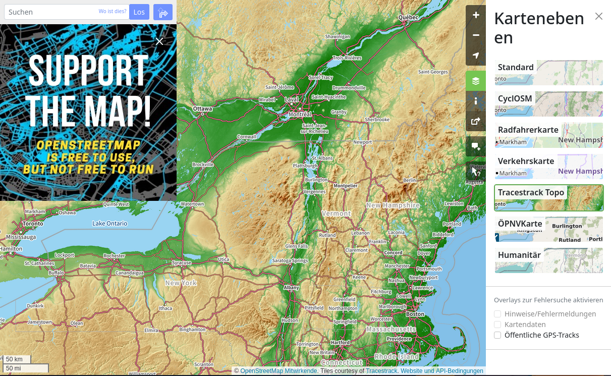
New Map Style “Tracestrack Topo” [] map data © OpenStreetMap contributors
Mapping
- barefootstache outlined his experience of mapping the coastal towns of Croatia.
- CharliePlett shared his experience of mapping all the landcover in Belize.
- Denrazir recounted his experience when mapping the distribution of tree species at the University of the Philippines Diliman campus.
- n8dx announced that the pedestrian network for the city of Paris is almost complete. In particular, it provides precise guidance for people with visual impairments. You can find more details in an article by SonarVision, which is developing a GPS application for adapted guidance.
- Pierre Béland has released a JOSM-style waterways mapcss to ease the process of editing waterway in JOSM.
- M!dgard has written a proposal on refining access restrictions.
Mapping campaigns
- Charmyne Mamador shared her experiences when participating in the ‘MapaTalks‘ at De La Salle University, ‘Make the Map Ausome‘ at the Polytechnic University of the Philippines, and in the US-ASEAN Science, Technology, and Innovation Cooperation (US-ASEAN STIC) Conference’s Pitch Competition in Jakarta.
Community
- Ponciano da Costa de Jesus reported on the activities of the Timor Leste G-SIG during July to September 2023.
- Udayana RS and GIS blogged about their OpenStreetMap workshops held at Udayana University, Denpasar, Indonesia.
- Andrii Holovin has reworked the website Welcome Mat. It now has features like internationalisation support and dark/light modes. These features were built using Material for MkDocs. Andrii invites everyone to help and improve the resource.
- Even on GNU/Linux in Switzerland, people are making fun of Google’s ‘Road Mapper’ project and find it immoral that the richest corporation in the world is looking for volunteers to work for free. Instead, GNU/Linux.ch recommends getting involved with OpenStreetMap. In summary, the article has well written arguments and visual examples.
Events
- Asif Bin Alam Seum reflected on this year’s activities of YouthMappers at SUST, Bangladesh.
Education
- Just van den Broecke published documentation from the workshop ‘OpenStreetMap, smart mapping with Apps’, held in the city of Middelburg, Netherlands.
Maps
- [1] The new map style ‘Tracestrack Topo’ is now available on OpenStreetMap’s website.
- The German Federal Office of Cartography and Geodesy announced that they have updated the data for the TopPlusOpen presentation graphics. Further on Mastodon, the Office tooted that the map is based on official geodata and OpenStreetMap data.
- Jochen Topf has built an OpenStreetMap-based vector map tile prototype that updates every minute.
- According to netzpolitik.org, Amnesty International has criticised the restriction of freedom of assembly in Germany. On an OSM-based interactive ‘Protest Map‘ you can view the respective violations worldwide.
Open Data
- Yandex has released a Russian-language dataset of reviews of organisations that were published on Yandex Maps.
Licences
- Christoph Hormann commented on the licence issue arising from adding the new map style ‘Tracestrack Topo’ to OpenStreetMap’s website.
Software
- Junzhen published their Google Summer of Code 2023 project’s final report on incorporating a landmark-based navigation system into the Valhalla routing engine.
- Tracestrack has released the ‘OpenStreetMap Localisation Tool‘, a web application to make it easier to translate place names on OpenStreetMap.
- kadi4 announced the release of ‘OsmoTagger’, an OpenStreetMap editor for the iOS platform.
Programming
- whammo has released a VS Code extension that highlights MapCSS syntax. It will improve code readability for .mapcss and JOSM validator files, and is available directly from the VS Code Marketplace.
Releases
- Organic Maps version 2023.09.22-27-android has been released. This version comes with improvements to the voice-based navigation feature.
Did you know …
- … that you can quickly draw complex curved lines in iD by pressing the space bar and just moving the mouse? There is a FastDraw plugin for the same feature in JOSM.
- … of the public bookcases map, where you can find public bookcases that allow you to add and/or take out books for free?
OSM in the media
- Australia’s ABC News reported on the crosswalk wait timer app created by Jake Coppinger.
Other “geo” things
- GeoParquet released version 1.0.0. It is a geospatial data storage format, which is based on Apache Parquet.
- Claire Giodarno, on the Path To Citus Con podcast, interviewed Paul Ramsey and Regina Obe, who are members of the PostGIS extension development team.
Note:
If you like to see your event here, please put it into the OSM calendar. Only data which is there, will appear in weeklyOSM.
This weeklyOSM was produced by MatthiasMatthias, Strubbl, TheSwavu, TrickyFoxy, andygol, barefootstache, derFred.
We welcome link suggestions for the next issue via this form and look forward to your contributions.