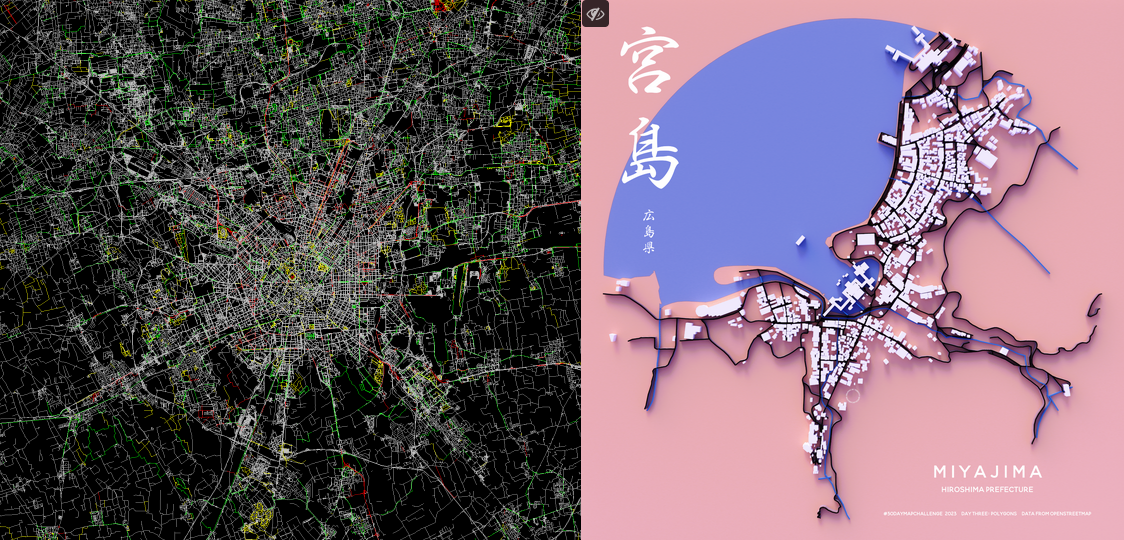
Just two of the impressive examples created from OSM data in the 30DayMapChallenge. [] | © Jacopo Farina & terence | map data © OpenStreetMap contributors
Mapping
- AgusQui shared his experience of trying to map railway signalling on the Sarmiento line (Once Station – Moreno Station) in Buenos Aires City, Argentina.
- Andres Gomez Casanova described the various alternatives for integrating OpenStreetMap data with data from Wikimedia projects. At the end of the article he pointed out that the ODbL licence used by OpenStreetMap can sometimes be incompatible with the CC-BY licence used by Wikimedia.
- The OpenStreetMap community in Marikina City in the Philippines is planning to cycle through the city together and collect street-level imagery of the roads they will travel.
- Xtvn pondered some of the ethical questions regarding the GPS Traces feature on OpenStreetMap.
Mapping campaigns
- Tom Di Nunzio has proposed a project to import data from the Palenque Mapping Project’s archaeological research in the Chiapas region of Mexico to OpenStreetMap.
Community
- Professor Stefan Keller, from the OST Ostschweizer Fachhochschule, is working as a ‘mapper in residence’ in the city of Winterthur, Switzerland, for four Fridays in November 2023. The city administration described it as a win-win situation for the city and OpenStreetMap on LinkedIn with three clear benefits:
- Link between the city administration and the OSM community.
- Understanding of OSM among the organisation’s employees.
- Promoting the improvement of OpenStreetMap content and processes through the community.
We think this is highly recommended for imitation.
- Koreller has found two online sources with information about skyscrapers from all over the world. In his blog, he described how he took that opportunity to enrich several free projects with the buildings of Pyongyang; Wikidata, Wikimedia Commons, and OpenStreetMap.
- Matheus Gomes Correia blogged about using an Insta360 X3 camera for street-level imagery, which he investigated as part of of his PhD research. He concluded that the images are great, but the GPS software is not precise enough.
- Niels Elgaard Larsen reported about the maxspeed tag’s status and quality in Denmark.
OpenStreetMap Foundation
- A wiki page outlining information about the 17th Annual General Meeting of the OpenStreetMap Foundation has been created.
- Dorothea Kazazi announced that the October OpenStreetMap Foundation board meeting has resulted in two new decisions, namely approval of draft travel policy and the approval of advisory board coordinator role.
- Arnalie Vicario, a board member of the OpenStreetMap Foundation, asked the community for ideas on how to improve the current OSMF affiliation system.
Events
- OpenStreetMap Kerala have hosted their annual community meetup in Thrissur, Kerala, India. More than 70 OSM enthusiasts, users, and government officials joined to discuss using and improving OpenStreetMap data.
Maps
- Pierre Béland proposed, on the OSM Community forum, a map quiz where your challenge is to ‘locate on OpenStreetMap eight areas with a “Blue Map Style perspective”‘. Activate the Waterways JOSM style and download OSM data for your city or a coastal area. Pierre said that you should be surprised which major cities and coastal areas are represented. Other than JOSM edits, this style displays how water resource management varies across countries and can be managed in multiple ways. Use the JOSM Mappaint dialog box (F12 preferences/Mappaint) to download and activate the style. It renders only the natural and man-made water thematic content (water and waterways features) and hides other features.
- The 30-Day Map Challenge has been running since 1 November.
Unfortunately, we can only present a few examples, most of which use data from OSM. The selection is neither an order nor a rating.
For map lovers, the hashtag #30DayMapChallenge is your friend in November.
- Day 1: Points
- Street trees in Buenos Aires
- Anton van Tetering – All place names starting with ‘Bad’ in Germany
- watmildon – Density of private pools in one chunk of Phoenix Arizona
- ‘The European tripoint constelation’ (A tripoint is a geographical point at which the boundaries of 3 countries.)
- Day 2: Lines
- Cyclability of roads in Milan (dedicated, allowed, forbidden)
- stevefaeembra – London Tube Map.
- Street map + Water courses
- Day 3: Polygons
- Day 4: A bad map
- Day 5: Analogue map
- Day 1: Points
OSM in action
- elDiario.es, a Spanish online news site, has published an interactive map explaining the history of vertical housing in Spain.
Open Data
- Lat × Long reported on how Overture’s Global Entity Reference System hopes to improve data interoperability but it’s not there yet. Overture has assigned GERS IDs to more than 1.6 million building footprints across several cities in North America, South America, and Europe. But it seems that GERS is of little use outside of Overture’s ecosystem.
Software
- GeoDesk has published a new version of its OpenStreetMap database toolkit. Store the entire OSM planet in under 100 GB, run queries 50 times faster than SQL, and now with full scripting support for Python. Free and open-source.
Programming
- Kamil Monicz (NorthCrab), a member of the Polish OSM community, has just announced, on the OSM Community forum, that he is working on a complete code rewrite of osm.org and the publication of API 0.7, written entirely in Python. More details are available on GitHub.
Note:
If you like to see your event here, please put it into the OSM calendar. Only data which is there, will appear in weeklyOSM.
This weeklyOSM was produced by MatthiasMatthias, PierZen, Strubbl, TheSwavu, barefootstache, derFred, rtnf.
We welcome link suggestions for the next issue via this form and look forward to your contributions.